

Blog
What is the Durupinar Formation?
Posted by Alex Shipley. Interview by Elijah Snider. on Aug 22, 2026
High in the mountains of eastern Turkey, about 18 miles south of Mount Ararat, there's a ridge shaped almost exactly like a boat. It's roughly 515 feet long, pointed at one end, rounded at the other, and it has drawn arguments, expeditions, and pilgrims for more than sixty years. It's called the Durupinar formation, and depending on who you ask, it's either an accident of geology or the resting place of the famous Noah's Ark.
This article covers what the formation actually is, how it was found, why people connect it to Genesis, and why a team is heading back this year to take a closer look. That team, led by Noah's Ark Scans, is running the most in-depth search the site has seen, scanning and core-drilling to finally test what's beneath the surface. GiveSendGo had the opprotunity to speak with Andrew Jones, founder and lead researcher at Noah's Ark Scans, to ask him about the search. Watch it here.To help fund "The Search for Noah's Ark," click here. GiveSendGo is a partner in this fundraiser.
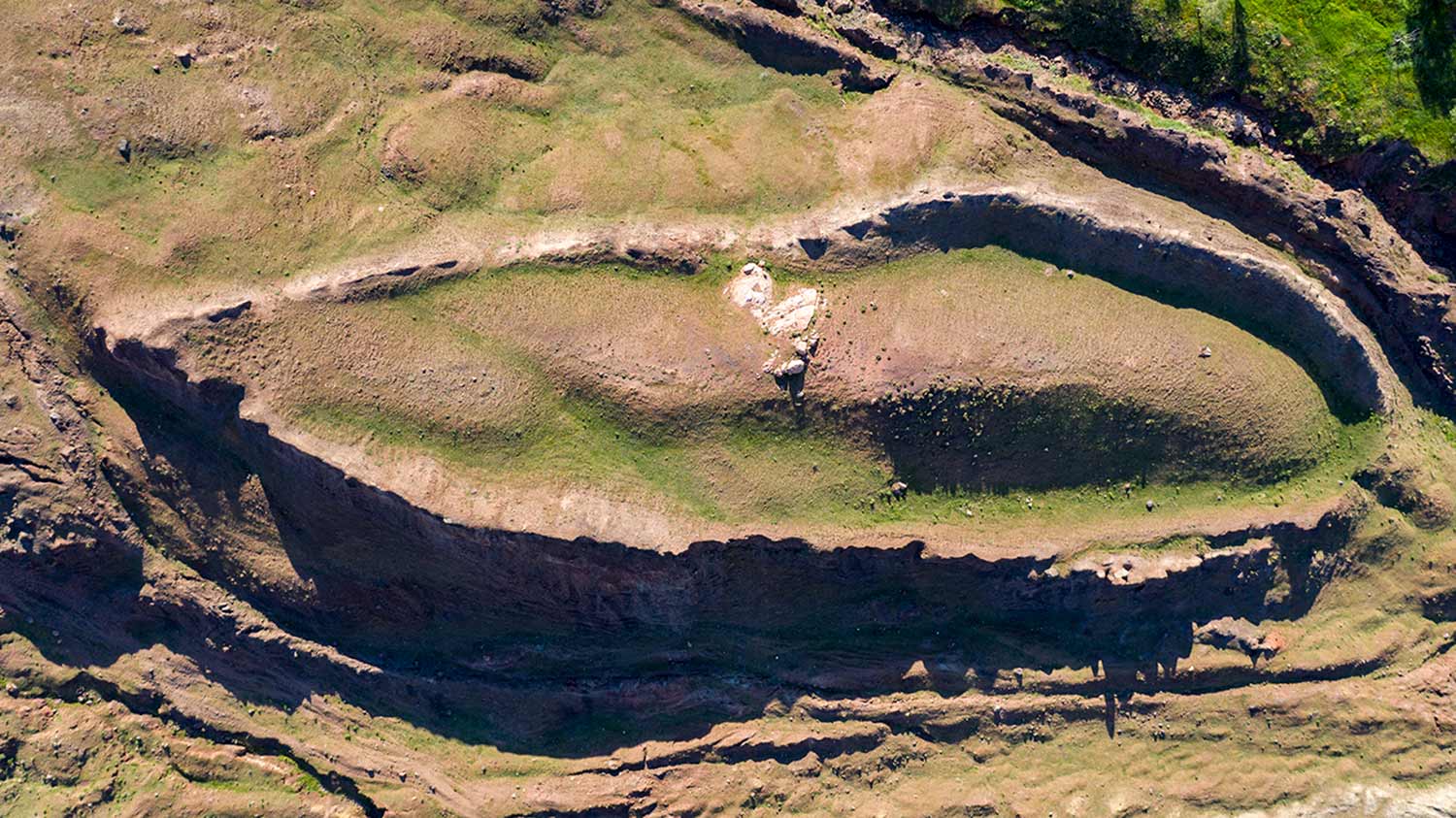
The Durupinar formation sits near the village of Uzengili, in the Agri Province of eastern Turkey, in the mountains not far from the Iranian border. From the air, it reads unmistakably as a unique shape: a long, teardrop outline pressed into the surrounding terrain, with raised sides and a pointed prow. On the ground, it's a low mound of earth and rock.
Its dimensions are the reason people keep coming back to it. The formation runs roughly 515 feet long, close to the 300 cubits Genesis gives for the ark. That length is the single detail that turns a strange-looking ridge into a question worth asking. Could this be the location of Noah's Ark's final resting place?
The formation gets its name from Captain Ilhan Durupinar, a Turkish army cartographer. In 1959, while reviewing aerial survey photographs of the region, he noticed a boat-shaped outline that didn't look like the land around it. The photos were published, and by the early 1960s the site had caught the attention of researchers and believers around the world. The Turkish photographer Ara Güler captured an iconic aerial image of it in 1961 that spread the story further.
The formation had likely been sitting there, unnoticed from the ground, for a very long time. It took an aerial view to make the shape obvious. Some researchers believe it emerged into view after earthquakes and heavy rains disturbed the surrounding mud in the mid-20th century, which is part of why one way to describe it is buried, not hidden.
Genesis 8:4 says the ark came to rest "on the mountains of Ararat" after the flood. For the full biblical background, see [Mount Ararat and Noah's Ark]. The Durupinar formation sits in that region, and it's boat-shaped, and it runs close to the length Scripture gives. For people who find those three facts hard to dismiss as coincidence, it's a compelling candidate.
"You're not gonna find a site like this anywhere in the world where you're looking at the actual object associated with this event in the book of Genesis," Jones said.
Over the decades, researchers have pointed to other details as well. In 2024, Noah's Ark Scans, the group now leading the 2026 search, took 88 soil samples from inside and outside the boat-shaped area, and reported that the samples from inside contained roughly three times more organic material than the ground just outside it, which they interpret as consistent with a large wooden structure decaying in place over time. Earlier ground-penetrating radar scans have also suggested angular structures and regularly spaced features several meters below the surface, patterns the researchers argue look more built than natural. None of this is proof, and the people doing the work are careful to say so. But it's enough to keep the question open, and the investigations fueled.
Plenty of geologists look at the Durupinar formation and see a natural feature, not a boat. The leading explanation is that it's the product of a mudflow and the erosion of softer rock around a more resistant core, a process that can leave behind streamlined, boat-like shapes without any human hand involved. A peer-reviewed paper in 1996, co-authored by researcher David Fasold and geologist Lorence Collins, argued the formation is a natural "syncline," a fold in sedimentary rock. Notably, Fasold had earlier been associated with the idea that the site might be the ark, then co-authored the paper concluding it wasn't.
Some Christians also argue it's the wrong site. Answers in Genesis, whose researchers fully believe the flood happened, has long maintained that Durupinar is a natural rock formation rather than the ark. Founder Ken Ham wrote in 2025 that "when Christians use poor, easily disproven, or inconclusive evidence for the truth of God's Word, it makes it easier for skeptics to dismiss everything that person has to say." His point isn't that the ark is a myth — it's that a shaky claim for the Bible can do more harm than a missing one, which is why he urges Christians to "exercise caution, look at the actual evidence, and avoid arguments based on conjecture."
That disagreement is exactly why the formation stays interesting. Decades of aerial photos, soil samples, and surface surveys haven't settled it, because the one thing that could settle it, pulling physical samples from deep inside the formation, hasn't been done. The site sits on protected land near a sensitive border region, so any investigation has to be carefully permitted and non-destructive, and until now no team had secured the permissions and tools to test what's actually underneath. The debate has been running in place, waiting on better data.
For a fuller look at both sides of the argument, see [the case for and against the Durupinar formation].
That's where the current expedition comes in. A research group called Noah's Ark Scans, working alongside Turkish academics and with official permits from Turkish government agencies, is bringing modern tools to the site, for the first time in decades at this level of technology.
The plan is deliberately non-destructive, and the researchers have laid it out in stages. First came a base survey: a professional crew set precise ground control points and flew a drone that captured around 4,000 photographs, enough to build a high-resolution 3D model of the entire site. Next comes deep radar, a type the team says has never been used in Turkey before, capable of reading nearly 100 meters down. "It's a way to look below the surface like a CAT scan," Jones explained, "and not have to disturb the soil and destroy the site, which is very fragile."
From there, the plan moves to roughly 200 soil samples taken inside and outside the formation for chemical comparison, and finally to the step that's never been successfully done here: core drilling. The team plans to drill deep into the formation, past whatever might remain of a vessel and down into the mountainside beneath it, pulling continuous cores of soil and rock for laboratory analysis. The drill bit itself is only about six inches wide against a 515-foot-long target, so the locations are chosen carefully in advance. And if the scans reveal a cavity, the team has a miniaturized camera probe, steerable "with a PlayStation controller," ready to send down and look directly.
The idea is simple: map first, then sample, then look.
Whether the results point toward something built or confirm a natural formation, the data itself is the goal. As Jones frames it, the honest question is still open — is this something made, or an extraordinary work of nature? More data is how you answer that.
Core drilling, radar surveys, and the analysis that follows all cost money. The team estimates this season's work at over a million dollars, and the expedition is being funded the way a lot of ambitious things are now: by everyday people who want to see the question answered. A fundraiser for the work launched on GiveSendGo, where anyone curious about what's under that ridge can help fund the going-in-to-look.
You don't have to be certain it's the ark to think the question is worth answering. That's the appeal of crowdfunding a search like this one. It turns a sixty-year argument into something a community can actually act on, together.
Want to follow the expedition or help fund it? Support “The Search for Noah’s Ark” here. GiveSendGo is a partner in this fundraiser.
This article covers what the formation actually is, how it was found, why people connect it to Genesis, and why a team is heading back this year to take a closer look. That team, led by Noah's Ark Scans, is running the most in-depth search the site has seen, scanning and core-drilling to finally test what's beneath the surface. GiveSendGo had the opprotunity to speak with Andrew Jones, founder and lead researcher at Noah's Ark Scans, to ask him about the search. Watch it here.To help fund "The Search for Noah's Ark," click here. GiveSendGo is a partner in this fundraiser.
Where It Is and What It Looks Like
The Durupinar formation sits near the village of Uzengili, in the Agri Province of eastern Turkey, in the mountains not far from the Iranian border. From the air, it reads unmistakably as a unique shape: a long, teardrop outline pressed into the surrounding terrain, with raised sides and a pointed prow. On the ground, it's a low mound of earth and rock.
Its dimensions are the reason people keep coming back to it. The formation runs roughly 515 feet long, close to the 300 cubits Genesis gives for the ark. That length is the single detail that turns a strange-looking ridge into a question worth asking. Could this be the location of Noah's Ark's final resting place?
How It Was Discovered
The formation gets its name from Captain Ilhan Durupinar, a Turkish army cartographer. In 1959, while reviewing aerial survey photographs of the region, he noticed a boat-shaped outline that didn't look like the land around it. The photos were published, and by the early 1960s the site had caught the attention of researchers and believers around the world. The Turkish photographer Ara Güler captured an iconic aerial image of it in 1961 that spread the story further.
The formation had likely been sitting there, unnoticed from the ground, for a very long time. It took an aerial view to make the shape obvious. Some researchers believe it emerged into view after earthquakes and heavy rains disturbed the surrounding mud in the mid-20th century, which is part of why one way to describe it is buried, not hidden.
Why People Connect It to Noah's Ark
Genesis 8:4 says the ark came to rest "on the mountains of Ararat" after the flood. For the full biblical background, see [Mount Ararat and Noah's Ark]. The Durupinar formation sits in that region, and it's boat-shaped, and it runs close to the length Scripture gives. For people who find those three facts hard to dismiss as coincidence, it's a compelling candidate.
"You're not gonna find a site like this anywhere in the world where you're looking at the actual object associated with this event in the book of Genesis," Jones said.
Over the decades, researchers have pointed to other details as well. In 2024, Noah's Ark Scans, the group now leading the 2026 search, took 88 soil samples from inside and outside the boat-shaped area, and reported that the samples from inside contained roughly three times more organic material than the ground just outside it, which they interpret as consistent with a large wooden structure decaying in place over time. Earlier ground-penetrating radar scans have also suggested angular structures and regularly spaced features several meters below the surface, patterns the researchers argue look more built than natural. None of this is proof, and the people doing the work are careful to say so. But it's enough to keep the question open, and the investigations fueled.
What Skeptics Say
Plenty of geologists look at the Durupinar formation and see a natural feature, not a boat. The leading explanation is that it's the product of a mudflow and the erosion of softer rock around a more resistant core, a process that can leave behind streamlined, boat-like shapes without any human hand involved. A peer-reviewed paper in 1996, co-authored by researcher David Fasold and geologist Lorence Collins, argued the formation is a natural "syncline," a fold in sedimentary rock. Notably, Fasold had earlier been associated with the idea that the site might be the ark, then co-authored the paper concluding it wasn't.
Some Christians also argue it's the wrong site. Answers in Genesis, whose researchers fully believe the flood happened, has long maintained that Durupinar is a natural rock formation rather than the ark. Founder Ken Ham wrote in 2025 that "when Christians use poor, easily disproven, or inconclusive evidence for the truth of God's Word, it makes it easier for skeptics to dismiss everything that person has to say." His point isn't that the ark is a myth — it's that a shaky claim for the Bible can do more harm than a missing one, which is why he urges Christians to "exercise caution, look at the actual evidence, and avoid arguments based on conjecture."
That disagreement is exactly why the formation stays interesting. Decades of aerial photos, soil samples, and surface surveys haven't settled it, because the one thing that could settle it, pulling physical samples from deep inside the formation, hasn't been done. The site sits on protected land near a sensitive border region, so any investigation has to be carefully permitted and non-destructive, and until now no team had secured the permissions and tools to test what's actually underneath. The debate has been running in place, waiting on better data.
For a fuller look at both sides of the argument, see [the case for and against the Durupinar formation].
The 2026 Research Effort
That's where the current expedition comes in. A research group called Noah's Ark Scans, working alongside Turkish academics and with official permits from Turkish government agencies, is bringing modern tools to the site, for the first time in decades at this level of technology.
The plan is deliberately non-destructive, and the researchers have laid it out in stages. First came a base survey: a professional crew set precise ground control points and flew a drone that captured around 4,000 photographs, enough to build a high-resolution 3D model of the entire site. Next comes deep radar, a type the team says has never been used in Turkey before, capable of reading nearly 100 meters down. "It's a way to look below the surface like a CAT scan," Jones explained, "and not have to disturb the soil and destroy the site, which is very fragile."
From there, the plan moves to roughly 200 soil samples taken inside and outside the formation for chemical comparison, and finally to the step that's never been successfully done here: core drilling. The team plans to drill deep into the formation, past whatever might remain of a vessel and down into the mountainside beneath it, pulling continuous cores of soil and rock for laboratory analysis. The drill bit itself is only about six inches wide against a 515-foot-long target, so the locations are chosen carefully in advance. And if the scans reveal a cavity, the team has a miniaturized camera probe, steerable "with a PlayStation controller," ready to send down and look directly.
The idea is simple: map first, then sample, then look.
Whether the results point toward something built or confirm a natural formation, the data itself is the goal. As Jones frames it, the honest question is still open — is this something made, or an extraordinary work of nature? More data is how you answer that.
How the Search Is Being Funded
Core drilling, radar surveys, and the analysis that follows all cost money. The team estimates this season's work at over a million dollars, and the expedition is being funded the way a lot of ambitious things are now: by everyday people who want to see the question answered. A fundraiser for the work launched on GiveSendGo, where anyone curious about what's under that ridge can help fund the going-in-to-look.
You don't have to be certain it's the ark to think the question is worth answering. That's the appeal of crowdfunding a search like this one. It turns a sixty-year argument into something a community can actually act on, together.
Want to follow the expedition or help fund it? Support “The Search for Noah’s Ark” here. GiveSendGo is a partner in this fundraiser.
Comments
There are no comments yet. Be the first to add a comment below!
Leave a Comment
Fields with * are requiredGiveSendGo
The place where help and hope go hand-in-hand.
