

Blog
Photos from the Noah’s Ark Site: Durupinar Up Close
Posted by Alex Shipley. Interview by Elijah Snider. on Aug 22, 2026
Some people look at these photos and see the hull of a ship. Others see a trick of mud and rock. For sixty years, the same boat-shaped ridge in eastern Turkey has split everyone who's laid eyes on it into those two camps, and now, up close, you can decide what you see. Do you think this location is worth investigating as the final resting place of Noah's Ark?
It's called the Durupinar formation, and it sits about 18 miles south of Mount Ararat, near the Iranian border, roughly where Genesis says the ark came to rest.
What makes it worth a closer look isn't a single dramatic photo. It's the way the same piece of ground has been documented across six decades, from a famous aerial shot in the 1960s to ground-penetrating radar that reads what's beneath the surface today. This year, a team led by Noah's Ark Scans is running the most in-depth search the site has seen, scanning and core-drilling to finally test what's beneath the surface. To help fund "The Search for Noah's Ark," click here. GiveSendGo is a partner in this fundraiser.
Here's the site up close, with some context on what you're actually looking at, and why each image matters to the people studying it.
For the fuller story of the 2026 search happening this year, see [Inside the 2026 Search at Durupinar]. For what the Bible actually says about where the ark landed, see [Mount Ararat and Noah's Ark]. Watch GiveSendGo's full interview with Andrew Jones, founder and lead researcher at Noah's Ark Scans, here.

The 1961 aerial photograph by Ara Guler that brought the Durupinar formation to worldwide attention.
This 1961 aerial photograph, taken by the renowned Turkish photographer Ara Güler, is the image that brought the Durupinar formation to worldwide attention. The boat-shaped outline is unmistakable from the air, which is exactly what has kept the question alive for so long. It's worth noting the formation was first flagged two years earlier, in 1959, by a Turkish army captain reviewing aerial mapping photographs. Güler's photo is what made the rest of the world look.
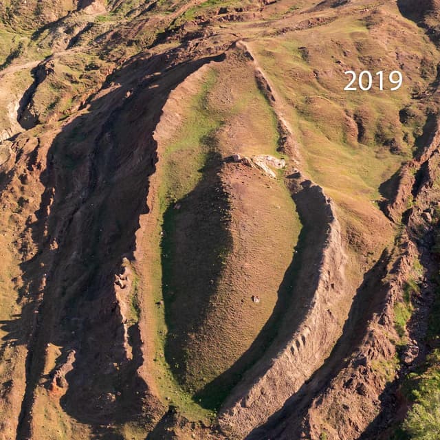
A 2019 drone view showing the full scope of the formation.
Modern drone photography shows the full scope of the formation in a way the 1961 image couldn't. For the 2026 survey, the team flew a drone that captured roughly 4,000 photographs with sub-centimeter GPS accuracy, enough to build a detailed 3D model of the entire site. Researchers measure it at roughly 157 meters (about 515 feet) long, a figure they note lines up closely with the dimensions Genesis gives for the ark. Skeptics point out that mudflow and erosion can produce elongated, boat-like ridges on their own. Both things can be true at once, which is why the surface photos alone have never settled the debate.
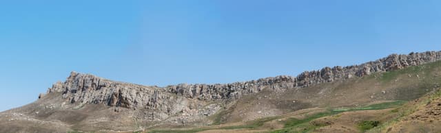
The limestone escarpment ridge directly above the formation, shown in its surrounding landscape.
This is the limestone escarpment ridge directly above the formation. Some who study the site believe the first settlement after the flood may have been located just below this ridge, though that's an interpretation, not an established finding. It's included here because it shows the formation in its actual landscape, not floating in isolation the way a cropped photo can suggest.
This is where the 2026 search by the team at Noah's Ark Scans is focused. Nothing below has been physically confirmed yet, but these scans point to what might be underneath, and the team’s 2026 core drilling is meant to test whether it holds up. Core drilling pulls up narrow, continuous columns of soil and rock from deep inside the formation — the first time material from that depth would be examined directly, in a lab, instead of read from a scan at the surface.
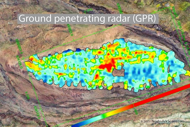
A drone photograph overlaid with ground-penetrating radar results.
Here a drone photograph is overlaid with results from ground-penetrating radar. Some of the most-discussed readings came from a 2019 scan, run by a professional survey crew brought in for a television documentary. Jones describes the moment the data came in: the technician began seeing "parallel lines going across the screen and perpendicular lines forming right angles" roughly nine feet down — in the technician's words, "we're actually seeing structure below the ground." Right angles rarely occur through natural geological processes, which the team interprets as a sign of possible intentional structure. Critics counter that subsurface radar is notoriously open to interpretation, and that "anomalies" are not the same as walls.
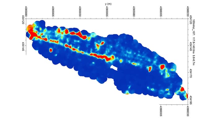
A 100 MHz ground-penetrating radar scan. Red areas mark what researchers describe as possible tunnel-like features.
This is a ground-penetrating radar scan at 100 MHz. The red areas are what the researchers describe as possible tunnel-like features running along the center of the formation and inside one edge of the "hull." The 2026 season is deploying a newer, more powerful radar the team says can read nearly 100 meters down, far deeper than earlier surveys reached. In an August 2026 press release, the team reported that this deeper radar had scanned the formation without finding the solid bedrock floor a natural rock feature would normally show, though they're careful to note that's a lead worth testing, not a conclusion. Whether these features are corridors, voids, or ordinary variations in rock and sediment is precisely the question the core drilling is meant to answer, by pulling physical material a lab can actually test.

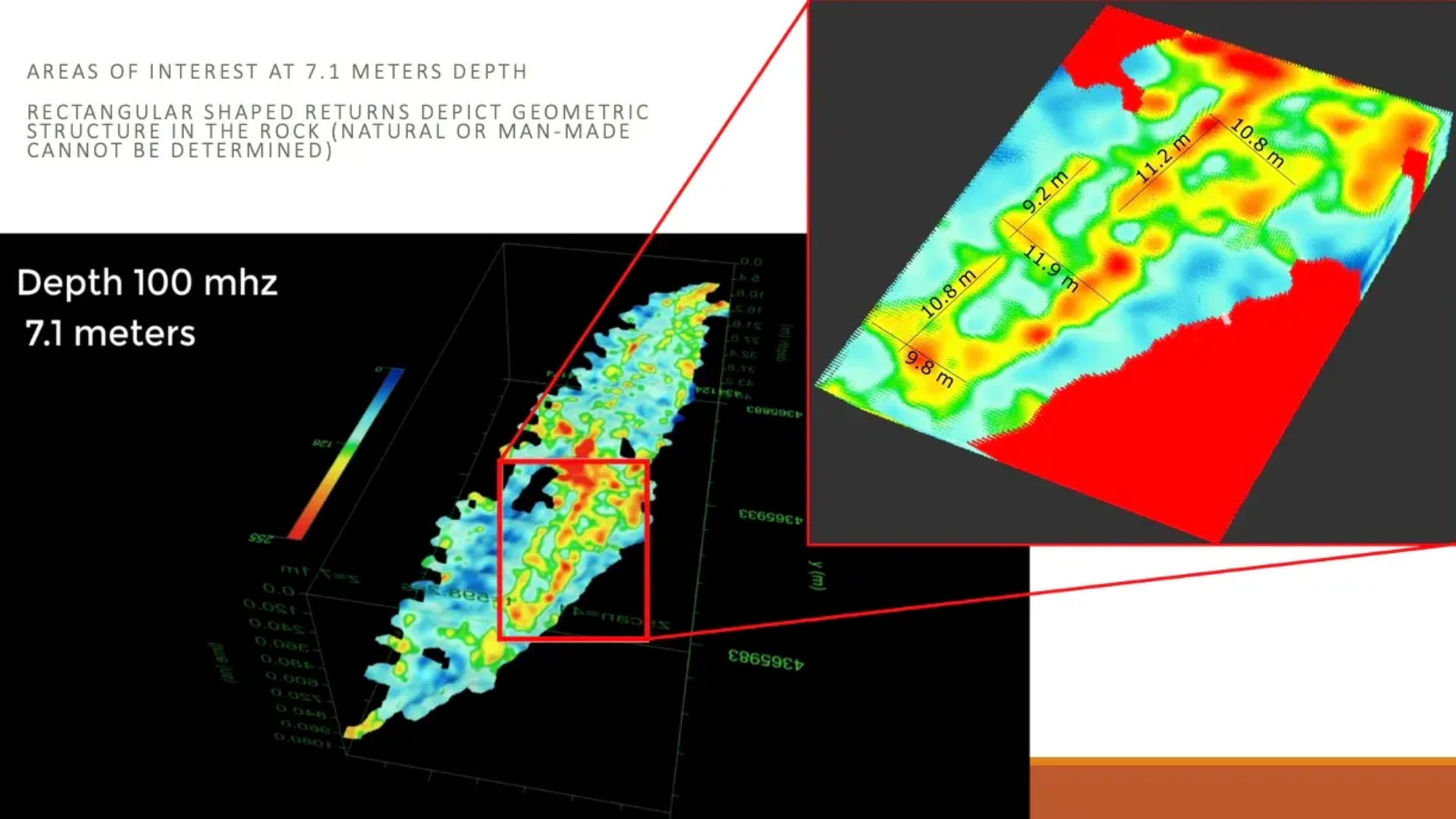
Angular subsurface features detected about 7 meters down, among the readings the team finds most compelling.
The team points to angular subsurface features like these, detected about 7 meters down, as among their most compelling readings. It's also fair to say no wood, worked timber, or man-made object has yet been recovered and independently verified from the site. The scans raise the question and fuel continued investigation today.
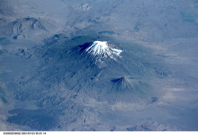
A view from the International Space Station showing the broader Mount Ararat region. Credit: NASA.
This photograph from the International Space Station shows the broader Mount Ararat region where the formation sits. It's a useful reminder that "the mountains of Ararat" in Genesis 8:4 describes a whole region, not one single peak, which is part of why a formation 18 miles from the summit of Mount Ararat is still within the biblically plausible area. We unpack that fully in [Mount Ararat and Noah's Ark].
For sixty years, the Durupinar formation has been something people could only photograph from the outside and argue about. What's different now is that the same site is being read from the inside, with radar, resistivity, and, in 2026, physical core samples. The images on this page are the visual record of a question moving from "what does it look like?" toward "what's actually down there?"
The honest answer today is that we don't know yet. But that’s the whole reason the current search is worth following. It might confirm what people have hoped for generations. It might not. Both outcomes are worth documenting honestly.
GiveSendGo is a partner in “The Search for Noah’s Ark” fundraiser by Noah’s Ark Scans, helping support this research — not to declare what the team will find, but to help make sure the question finally gets a rigorous, testable answer.
Follow the search and help fund the dig here.
Images courtesy of Noah’s Ark Scans’ website, fundraiser, and Facebook page.
It's called the Durupinar formation, and it sits about 18 miles south of Mount Ararat, near the Iranian border, roughly where Genesis says the ark came to rest.
What makes it worth a closer look isn't a single dramatic photo. It's the way the same piece of ground has been documented across six decades, from a famous aerial shot in the 1960s to ground-penetrating radar that reads what's beneath the surface today. This year, a team led by Noah's Ark Scans is running the most in-depth search the site has seen, scanning and core-drilling to finally test what's beneath the surface. To help fund "The Search for Noah's Ark," click here. GiveSendGo is a partner in this fundraiser.
Here's the site up close, with some context on what you're actually looking at, and why each image matters to the people studying it.
For the fuller story of the 2026 search happening this year, see [Inside the 2026 Search at Durupinar]. For what the Bible actually says about where the ark landed, see [Mount Ararat and Noah's Ark]. Watch GiveSendGo's full interview with Andrew Jones, founder and lead researcher at Noah's Ark Scans, here.
The Photo That Started the Conversation (1961)
The 1961 aerial photograph by Ara Guler that brought the Durupinar formation to worldwide attention.
This 1961 aerial photograph, taken by the renowned Turkish photographer Ara Güler, is the image that brought the Durupinar formation to worldwide attention. The boat-shaped outline is unmistakable from the air, which is exactly what has kept the question alive for so long. It's worth noting the formation was first flagged two years earlier, in 1959, by a Turkish army captain reviewing aerial mapping photographs. Güler's photo is what made the rest of the world look.
The Formation From Above Today
A 2019 drone view showing the full scope of the formation.
Modern drone photography shows the full scope of the formation in a way the 1961 image couldn't. For the 2026 survey, the team flew a drone that captured roughly 4,000 photographs with sub-centimeter GPS accuracy, enough to build a detailed 3D model of the entire site. Researchers measure it at roughly 157 meters (about 515 feet) long, a figure they note lines up closely with the dimensions Genesis gives for the ark. Skeptics point out that mudflow and erosion can produce elongated, boat-like ridges on their own. Both things can be true at once, which is why the surface photos alone have never settled the debate.
The limestone escarpment ridge directly above the formation, shown in its surrounding landscape.
This is the limestone escarpment ridge directly above the formation. Some who study the site believe the first settlement after the flood may have been located just below this ridge, though that's an interpretation, not an established finding. It's included here because it shows the formation in its actual landscape, not floating in isolation the way a cropped photo can suggest.
What the Scans Suggest Is Underneath
This is where the 2026 search by the team at Noah's Ark Scans is focused. Nothing below has been physically confirmed yet, but these scans point to what might be underneath, and the team’s 2026 core drilling is meant to test whether it holds up. Core drilling pulls up narrow, continuous columns of soil and rock from deep inside the formation — the first time material from that depth would be examined directly, in a lab, instead of read from a scan at the surface.
A drone photograph overlaid with ground-penetrating radar results.
Here a drone photograph is overlaid with results from ground-penetrating radar. Some of the most-discussed readings came from a 2019 scan, run by a professional survey crew brought in for a television documentary. Jones describes the moment the data came in: the technician began seeing "parallel lines going across the screen and perpendicular lines forming right angles" roughly nine feet down — in the technician's words, "we're actually seeing structure below the ground." Right angles rarely occur through natural geological processes, which the team interprets as a sign of possible intentional structure. Critics counter that subsurface radar is notoriously open to interpretation, and that "anomalies" are not the same as walls.
A 100 MHz ground-penetrating radar scan. Red areas mark what researchers describe as possible tunnel-like features.
This is a ground-penetrating radar scan at 100 MHz. The red areas are what the researchers describe as possible tunnel-like features running along the center of the formation and inside one edge of the "hull." The 2026 season is deploying a newer, more powerful radar the team says can read nearly 100 meters down, far deeper than earlier surveys reached. In an August 2026 press release, the team reported that this deeper radar had scanned the formation without finding the solid bedrock floor a natural rock feature would normally show, though they're careful to note that's a lead worth testing, not a conclusion. Whether these features are corridors, voids, or ordinary variations in rock and sediment is precisely the question the core drilling is meant to answer, by pulling physical material a lab can actually test.
Angular subsurface features detected about 7 meters down, among the readings the team finds most compelling.
The team points to angular subsurface features like these, detected about 7 meters down, as among their most compelling readings. It's also fair to say no wood, worked timber, or man-made object has yet been recovered and independently verified from the site. The scans raise the question and fuel continued investigation today.
The Site in Its Setting
A view from the International Space Station showing the broader Mount Ararat region. Credit: NASA.
This photograph from the International Space Station shows the broader Mount Ararat region where the formation sits. It's a useful reminder that "the mountains of Ararat" in Genesis 8:4 describes a whole region, not one single peak, which is part of why a formation 18 miles from the summit of Mount Ararat is still within the biblically plausible area. We unpack that fully in [Mount Ararat and Noah's Ark].
Why These Images Are Significant
For sixty years, the Durupinar formation has been something people could only photograph from the outside and argue about. What's different now is that the same site is being read from the inside, with radar, resistivity, and, in 2026, physical core samples. The images on this page are the visual record of a question moving from "what does it look like?" toward "what's actually down there?"
The honest answer today is that we don't know yet. But that’s the whole reason the current search is worth following. It might confirm what people have hoped for generations. It might not. Both outcomes are worth documenting honestly.
GiveSendGo is a partner in “The Search for Noah’s Ark” fundraiser by Noah’s Ark Scans, helping support this research — not to declare what the team will find, but to help make sure the question finally gets a rigorous, testable answer.
Follow the search and help fund the dig here.
Images courtesy of Noah’s Ark Scans’ website, fundraiser, and Facebook page.
Comments
There are no comments yet. Be the first to add a comment below!
Leave a Comment
Fields with * are requiredGiveSendGo
The place where help and hope go hand-in-hand.
